On March 5, Asia Maritime Transparency Initiative (AMTI) affiliated to the US-based Center for Strategic and International Studies (CSIS) issued an article titled The Long Patrol: Staredown at Thitu Island Enters its Sixteenth Month, which claims that the almost constant presence of China’s militia fishing vessels around Thitu Island is stoking up the “Thitu Island Crisis” again.
AMTI claims that China first deployed militia vessels around Thitu Island in December 2018 in response to Philippine efforts to repair the island’s runway and undertake other upgrades. There is an average of 18 Chinese ships around Thitu Island each day, peaking at hundreds of them, whose surveillance has continued for 16 months. As a result, the Philippines has made very little progress on its planned upgrades. AMTI even gives a partial interpretation of the number of Chinese ships around that area when the Philippines was carrying out landfill work, and conveys inaccurate information based on some satellite imagery.
Solely from the perspective of remote sensing technology, there are two logical fallacies in AMTI’s article.
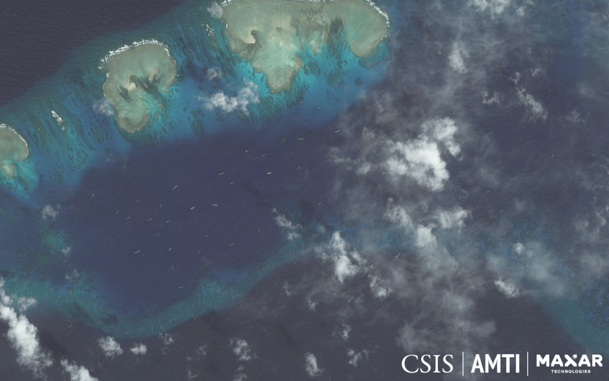
To begin with, these remote sensing images are incomplete with no timestamps, which cannot support AMTI’s views.
Of the 10 images cited in the article, none has specified the time. Time is a piece of key information for conducting analysis and research on remote sensing imagery, but it is not elaborated in this article. Why did the author conceal the time?
It is primarily because most images cited in the article were once posted on the website of AMTI in 2018 and the first half of 2019. This article, however, seeks to illustrate the activities of fishing vessels in the South China Sea from 2019 to February 2020. Since the time span of these images is inconsistent with that of this article, the author intentionally conceals timestamps on these images.
Above all, the article draws a chart about the number of Chinese fishing vessels around Thitu Island for 450 days, which is purportedly based on satellite images. Yet, has AMTI got hold of every day’s satellite image? Even if the article recognizes that it is only able to count vessels on 208 days, it should at least provide 208 images. To make it convincing, it has to disclose every day’s image. Otherwise, it only counts as conjecture.
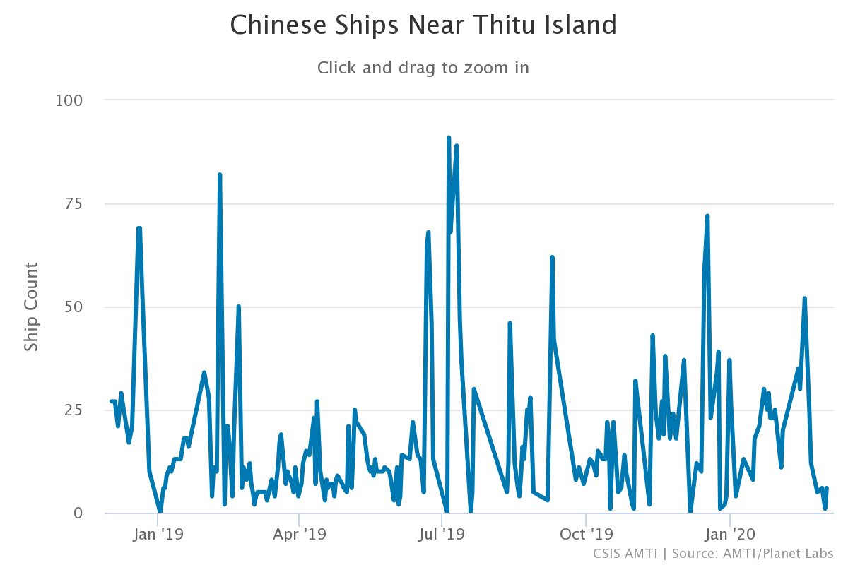
The number of Chinese fishing vessels around Thitu Island by AMTI
Second, existing remote sensing imagery has no way of identifying the nationality of vessels.
The article keeps emphasizing that these vessels shown in satellite images belong to China, and that they are militia fishing vessels. Because, as it argues, they show up at the wrong place with a suspicious track of activities.
The satellite data cited in the article is mostly satellite imagery from Maxar, which has high-resolution up to 0.31m. The technology allows us to identify large warships based on their shapes. However, it certainly cannot identify the nationality of fishing vessels weighing hundreds of tons or even tens of tons.
There is constant presence of Chinese, Vietnamese and Philippine vessels in the lagoons around Thitu Island. But the article insists on labeling all vessels there as Chinese ones, which is anything but convincing.
In addition, according to the AIS (Automatic Identification System), there were only a few Chinese fishing vessels near Thitu Island in the past year. We have not spotted any action taken by the Chinese government targeting Thitu Island recently, either.
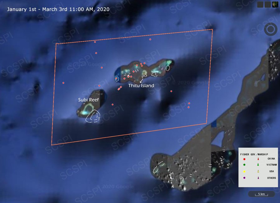
The track of five Chinese fishing vessels near Thitu Island from January 1, 2020 to March 3, 11:00 a.m., 2020
The red spots map out the track of Chinese fishing vessels, not the number of them. Source: SCSPI
According to the SCSPI, there were only five Chinese fishing vessels near Thitu Island in the past two months from January 1, 2020 to March 3, 11:00 a.m., 2020. Conversely, AMTI claims that there is an average of 18 Chinese ships around Thitu Island each day, peaking at hundreds of them, whose surveillance has continued for 16 months. The assertion is a far cry from the real statistics.
Just recently, the Philippine Department of National Defense (DND) Secretary Delfin Lorenzana has dismissed AMTI reports claiming that rehabilitation works at the Pag-asa Island(Thitu Island) were delayed by the constant presence of Chinese ships in the area.
“They have never in any way interfered with the rehab of the island."
Lorenzana said in a message to reporters on March 9th.
Appendix
Activities of five Chinese fishing vessels near Thitu Island from January 1, 2020 to March 3 11:00 a.m., 2020.
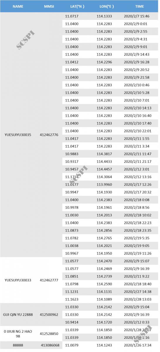
Source: SCSPI
Jiang Yanchuan

Jiang Yanchuan, General Manager of Beijing Kantian S&T Co.,Ltd., has devoted himself to remote sensing targets for many years, and is keen on providing leading remote sensing information services for industries through combination of remote sensing big data and artificial intelligence.