In recent years, the U.S. military has continuously increased the deployment and use of unmanned reconnaissance platforms in the South China Sea and surrounding areas. In particular, led by medium-to-high-altitude, long-endurance unmanned aerial vehicles (UAVs) such as the RQ-4 Global Hawk, MQ-4C Triton, and MQ-9 Reaper, the U.S. military has established an integrated, multi-dimensional aerial network for intelligence, surveillance, reconnaissance, and strike (ISR-Strike). These unmanned platforms, with their long-range loitering capability, modular sensor systems, and low-risk, high-frequency sortie advantages, have become a core supporting force for U.S. forward deployments and operations in the Western Pacific.
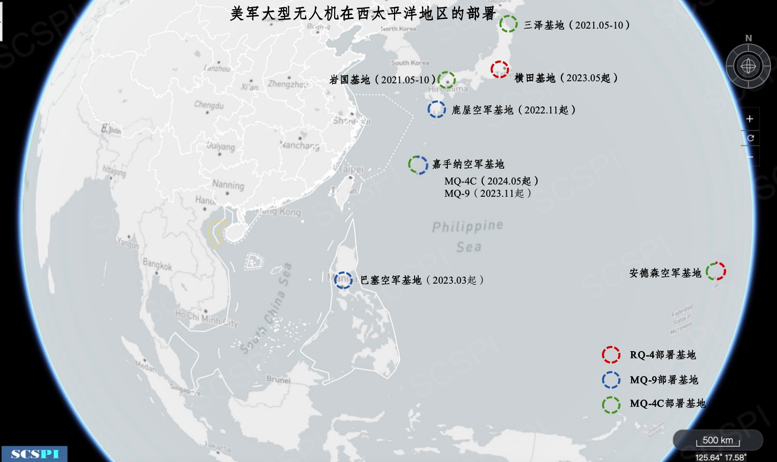
Figure 1. Deployment of Large U.S. UAVs in the Western Pacific
RQ-4 Global Hawk UAV
The RQ-4 UAV, operated by the U.S. Air Force (USAF), has a maximum speed of 644 km/h, a range of approximately 25,000 km, and an endurance of up to 36 hours, enabling intercontinental operations. It is a strategic, long-endurance, high-altitude “deep-look” ISR platform that complements satellites and manned ISR assets. The aircraft is equipped with advanced systems, including Synthetic Aperture Radar (SAR), Electro-Optical/Infrared (EO/IR) sensors, Signal Intelligence (SIGINT) collection systems, and Ground Moving Target Indicators (GMTI). These enable it to conduct sustained high-altitude reconnaissance over wide ground areas, giving it robust “deep-look” operational capabilities.

Figure 2. RQ-4 Global Hawk UAV
The RQ-4deployed in the Western Pacific is primarily operated by the 4th Reconnaissance Squadron at Andersen Air Force Base in Guam, though it is occasionally rotated to other operational detachments. For example, in January 2023, one RQ-4 was temporarily deployed to Changi, Singapore, coinciding with the port visit of the USS Nimitz Carrier Strike Group. On May 15, 2023, the USAF rotated the RQ-4 from Andersen Air Force Base to Yokota Air Base in Japan to support ongoing combat capabilities in the Indo-Pacific region. [1]
MQ-4C Triton UAV
The MQ-4C UAV is assigned to the U.S. Navy (USN), with the capability to loiter at an altitude of 17,000 meters for over 30 hours, and a maximum speed of 610 km/h. It’s equipped with the AN/ZPY-3 MFAS, a multi-function X-band electronically scanned array radar that provides 360° field-of-regard. This system can survey 7 million square kilometers of sea or land within 24 hours, offering multi-functional, all-weather, and round-the-clock reconnaissance and surveillance capabilities. As early as 2008, the MQ-4C was selected as a replacement for the EP-3E electronic reconnaissance aircraft. Its primary mission is to work with the P-8A anti-submarine patrol aircraft to jointly perform maritime ISR missions, thereby enhancing maritime situational awareness for the U.S. and its allied nations.

Figure 3 MQ-4C Triton UAV
In early 2020, the USN initiated the first deployment of two MQ-4C Triton UAVs to Guam, assigned to the 19th Unmanned Patrol Squadron (VUP-19). In May 2021, these two UAVs were temporarily deployed to Misawa Air Base and Marine Corps Air Station Iwakuni, before returning to Andersen Air Force Base in Guam in October 2021. The MQ-4C was deployed to Guam for a second time in September 2023, and has occasionally flown missions from Kadena. Since that time, MQ-4Cs have maintained a sustained presence in Guam. Between May and October 2024, two MQ-4Cs were additionally deployed to Kadena Air Base.[2] At present, both Kadena Air Base and Andersen Air Force Base host MQ-4C deployments.
According to incomplete statistics, from 2020 to July 2025, a total of 231 MQ-4C sorties were conducted in the Western Pacific, accumulating 2,200 hours of reconnaissance, with an average operational altitude of 14,841 meters per sortie. Due to flight distance and time-zone factors, MQ-4Cs launched from Andersen Air Force Base in Guam generally reach airspace near China during late-night or early-morning hours. Therefore, the earliest flight from Andersen depart at 19:00 Beijing time and latest one lands no later than 08:00 the next morning, with an average mission duration of 9.6 hours. In contrast, MQ-4Cs taking off from Kadena Air Base have their earliest takeoff at 03:00 and latest landing at 15:00, with flights usually occurring between 04:00 and 13:00.

Figure 4: USNMQ-4C (ICAO: AE6257)Activities in the Taiwan Strait and South China Sea in April 2025
MQ-9 Reaper UAV
The MQ-9 Reaper UAV, developed by General Atomics Aeronautical Systems for the U.S. military, is operated by both the USAF and the U.S. Marine Corps, primary for battlefield surveillance and strike missions. It first flew in 2001 and was delivered to military units in 2002. It has a maximum speed of 133 m/s and a cruising speed of 77–87 m/s. Its endurance reaches 30 hours during ISR missions, decreasing to 23 hours when it is fully loaded with weapons.

Figure 5: MQ-9 Reaper UAV
In March 2023, the MQ-9 was rotationally deployed for the first time to Basa Air Base, Philippines. This deployment, based on the Enhanced Defense Cooperation Agreement (EDCA) signed in 2014, is primarily used for maritime surveillance during the Balikatan exercises and for continuous monitoring of Second Thomas Shoal. [3]

Figure 6: Remote Sensing Image of Basa Air Base (20250810)
Since November 2023, the USAF has maintained a “long-term deployment” of eight MQ-9s at Kadena Air Base. These MQ-9s had previously been stationed at the Japan Maritime Self-Defense Force’s Kanoya Air Base in Kagoshima Prefecture, Kyushu, where they underwent a one-year “temporary deployment” beginning in November 2022 before being transferred to Kadena. The UAVs are under the command of Marine Unmanned Aerial Vehicle Squadron 3 (VMU-3), established in Hawaii, and constitutes the first Marine Corps Reaper UAV unit in the Indo-Pacific region, organizationally subordinate to the III Marine Expeditionary Force based in Japan. In August 2025, the Okinawa Defense Bureau of Japan’s Ministry of Defense notified the Okinawa Prefectural Government that the U.S. Marine Corps’ temporarily deployed MQ-9s at Kadena would be converted to an indefinite deployment. Furthermore, according to reports from July 2025, the U.S. plans to station MQ-9s at a South Korean Air Force base to initiate their first long-term rotational deployment in that country. [4]
Through the RQ-4’s high-altitude strategic early warning, the MQ-4C’s wide-area maritime surveillance, and the MQ-9’s tactical support and strike capabilities, the U.S. has established a layered and collaborative large-scale UAV ISR network in the South China Sea and its surrounding areas. The number of deployed bases and aircraft continues to increase. Currently, large U.S. UAV ISR sorties account for approximately 30% of all U.S. close-in aerial reconnaissance missions targeting China. In the future, their activity may even rival that of large manned reconnaissance aircraft.
Reference
[1] PACAF RQ-4 Global Hawks arrive at Yokota Air Base, May 28, 2023,
https://www.af.mil/News/Article-Display/Article/3407205/pacaf-rq-4-globa...
[2] US Triton UAVs to deploy from Japan, April 17, 2025,
https://www.asianmilitaryreview.com/2025/04/us-triton-uavs-to-deploy-fro...
[3] US Deploy MQ-9A Reaper Drones in Philippines to Support Intelligence Activities in South China Sea,June 5, 2024,
https://defencesecurityasia.com/en/us-deploy-mq-9a-reaper-drones-in-phil...
[4] Air Force plans to deploy MQ-9 Reaper to South Korea this year, reports say, July 22, 2025, https://www.stripes.com/branches/air_force/2025-07-22/reaper-drones-kuns...
SCSPI

With a view to maintaining and promoting the peace, stability and prosperity of the South China Sea, we launched the South China Sea Strategic Situation Probing Initiative (SCSPI) in April of 2019. The Initiative aims to integrate intellectual resources and open source information worldwide and keep track of important actions and major policy changes of key stakeholders and other parties involved. It will provide professional data services and analysis reports to parties concerned, helping them keep competition under control, and with a view to seek partnerships.