
Editor's Note:This Article examines the legal and geopolitical implications of the 2026 decision by Japan and the Philippines to negotiate exclusive-economic-zone and continental-shelf boundaries in waters east of Taiwan. It asks whether the contemplated area is legally separable from China’s claims, whether a bilateral line could prejudice third-party rights, what responses remain open to China, and which actor is altering the status quo. Beginning from the principle that the land dominates the sea, the Article argues that coastal projections from Taiwan’s eastern coast, Japan’s Sakishima/Yaeyama Islands, and the Philippines’ Batanes Islands may substantially overlap. The fact that Japanese and Philippine features lie less than 400 nautical miles apart establishes a possible bilateral overlap, but not an exclusively bilateral geography; continental-shelf entitlements may also extend beyond 200 nautical miles under Article 76 of UNCLOS. Because Japan and the Philippines have disclosed neither a negotiating map nor controlling base points, coordinates, or endpoints, they have not demonstrated the separability of the proposed delimitation area. Although a bilateral treaty cannot bind China without its consent, a fixed endpoint and the incorporation of coordinates into charts, licences, enforcement practices, or security arrangements could prejudice China’s legal and practical position. International jurisprudence therefore supports geographic restraint, open endpoints, and effective non-prejudice safeguards. China may preserve its claims through diplomatic representations, protests, and maritime presence according international and domestic law. Finally, the parallel expansion of Japan–Philippines defense cooperation creates a risk of securitizing the boundary and may blur their one-China positions by implying who is entitled to represent Taiwan-facing coasts.
On May 28, 2026, Japan and the Philippines upgraded their bilateral relationship to a “Comprehensive Strategic Partnership” in Tokyo. The same Joint Statement also outlined the initiation of formal negotiations to delimit the boundary between their respective exclusive economic zones and continental shelves.[1] Concerning defense matters, the statement confirmed that the Reciprocal Access Agreement had entered into force and had already been utilized in exercises including Balikatan 41-26. Moreover, the two countries signed an Acquisition and Cross-Servicing Agreement in January of the same year, launching discussions on an agreement for the protection of classified military information and promoting transfers of defense equipment such as destroyers, TC-90 aircraft, and coastal radar systems. On May 31, the two defense ministers struck a deal to proceed with the transfer of decommissioned Abukuma-class destroyers and a TC-90 aircraft, while continuing consultations on personnel training, maintenance support, equipment management, and information cooperation.[2]
The Japan–Philippines maritime delimitation process has thus unfolded in parallel with the development of the two countries’ defense mechanisms, joint operations, and maritime-capability cooperation. On June 2, the Ministry of Foreign Affairs of China stated that, as the contemplated waters lie east of Taiwan Island where China has an exclusive economic zone and continental shelf, China's participation in the delimitation is indispensable; and that Japan and the Philippines, by commencing negotiations without China, had violated international law and infringed upon China’s maritime rights and interests. On June 6, the Ministry of Transport of China organized forces of maritime administration, navigation support, and rescue to launch a special law-enforcement operation targeting maritime traffic in waters east of Taiwan Island. The China Coast Guard subsequently announced regular law-enforcement patrols in the relevant waters.[3] On August 14, Philippine President Ferdinand Marcos Jr. expected that the negotiations could be concluded by the end of the year, regarding no major obstacles and characterizing the contemplated agreement as essentially a “bilateral matter” between Japan and the Philippines.[4]
There arise five interrelated questions: Are Japan and the Philippines entitled to proceed unilaterally with the delimitation of exclusive economic zones and continental shelves in waters east of Taiwan? Is the contemplated Japan–Philippines delimitation separable from China’s claims? Would such a delimitation encroach upon or appropriate China’s exclusive-economic-zone and continental-shelf entitlements east of Taiwan Island? Is China entitled to make diplomatic representations and protests and to conduct maritime law-enforcement patrols in the relevant waters? And which side, ultimately, is attempting to change the status quo there?
I. The Claims of China, Japan, and the Philippines in Waters East of Taiwan Substantially Overlap
In maritime delimitation, “the land dominates the sea” is a fundamental principle: maritime entitlements are derived from the geographical projection of coasts.[5] The relevant Japanese and Philippine land features are located less than 400 nautical miles apart. That fact may indicate that their respective maximum 200-nautical-mile entitlements overlap, but it does not mean that projections from other relevant coasts are excluded from that area.
Publicly available geographical materials show that Taiwan’s eastern coast is a long and continuous main-island coast facing the Philippine Sea Basin. Japan’s claimed entitlements would come principally from the Sakishima/Yaeyama island chain, while the Philippines relies on the Batanes Islands to its north and on its archipelagic baselines. If the Japan–Philippines boundary were extended westward or southwestward and enclosed the tripoint, the resulting cut-off could affect not only the projection of an isolated offshore island, but also the maritime space generated by Taiwan’s continuous eastern coast together with Orchid Island(Lan Yu) and Green Island(Lü Dao).[6]
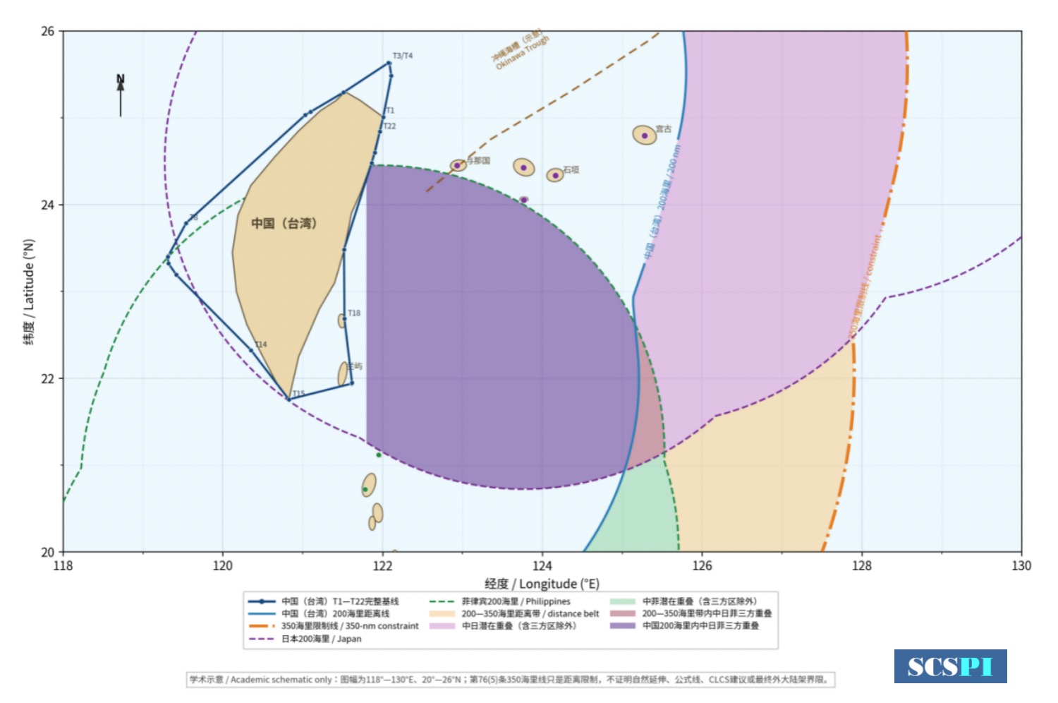
Figure 1. Map of the 350-Nautical-Mile Limit East of Taiwan Source: Created by the author
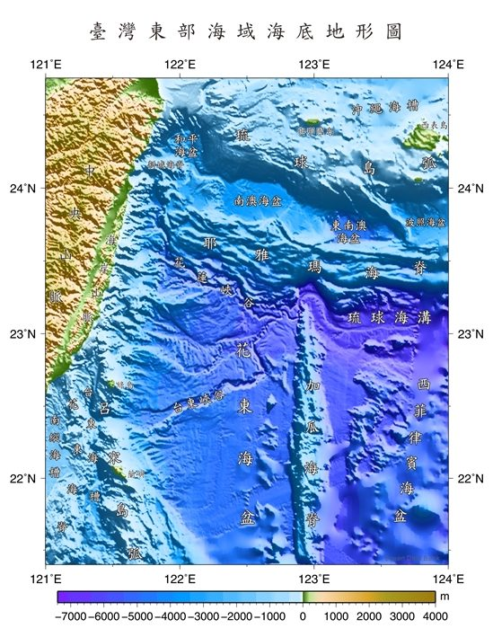
Figure 2. Seafloor Topographic Map of the Waters East of Taiwan Source: Ocean Data Bank,https://www.odb.ntu.edu.tw/bathy/colorimages/
Another issue concerns what kind of effect should be given, in a concrete delimitation, to relatively small islands such as Yonaguni, Ishigaki, Iriomote, Batan, Itbayat, and Sabtang against Taiwan’s continuous coast. Without such an assessment, no bilateral line segment drawn using those islands as basepoints can be proven to be equitable solely on the basis of geometric overlap.[7] In addition, islands like Orchid Island and Green Island may also modify the local geographical relationship. If the same waters lie within the maximum potential entitlements of three sides, Japan and the Philippines must demonstrate that the contemplated segment does not necessitate a prior determination of the effect to be accorded to Taiwan’s relevant coasts. Likewise, placing the contemplated boundary “beyond 200 nautical miles from Taiwan” does not fully resolve the question.[8] For the exclusive economic zone, 200 nautical miles may serve as an initial screening criterion. For the continental shelf, however, entitlements that meet the requirements of Article 76 of UNCLOS may extend beyond 200 nautical miles.[9] It must also be clarified whether the 200 nautical miles are measured from the low-water line of Taiwan’s main island, from the applicable baselines, or from offshore islands. A cartographic arc drawn for convenience cannot replace a complete analysis of title, baselines, and relevant coasts.
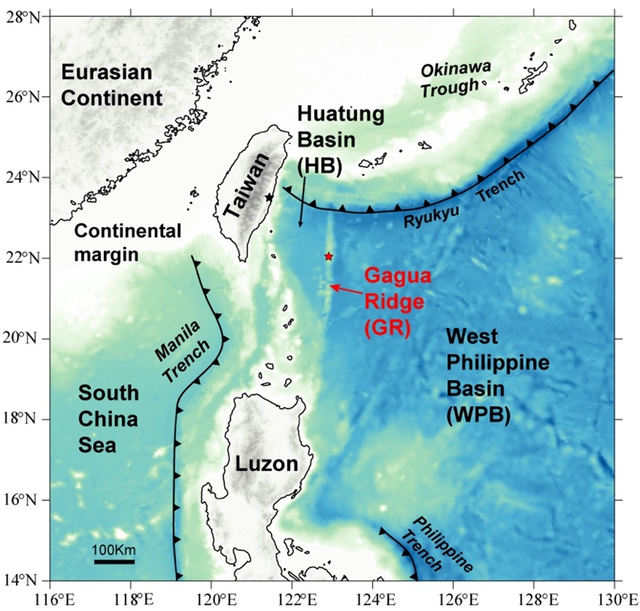
Figure 3. Geological Map of the Gagua Ridge and Adjacent Areas Source: Qian, Shengping, et al. "First identification of a Cathaysian continental fragment beneath the Gagua Ridge, Philippine Sea, and its tectonic implications." Geology 49.11 (2021): 1332-1336.
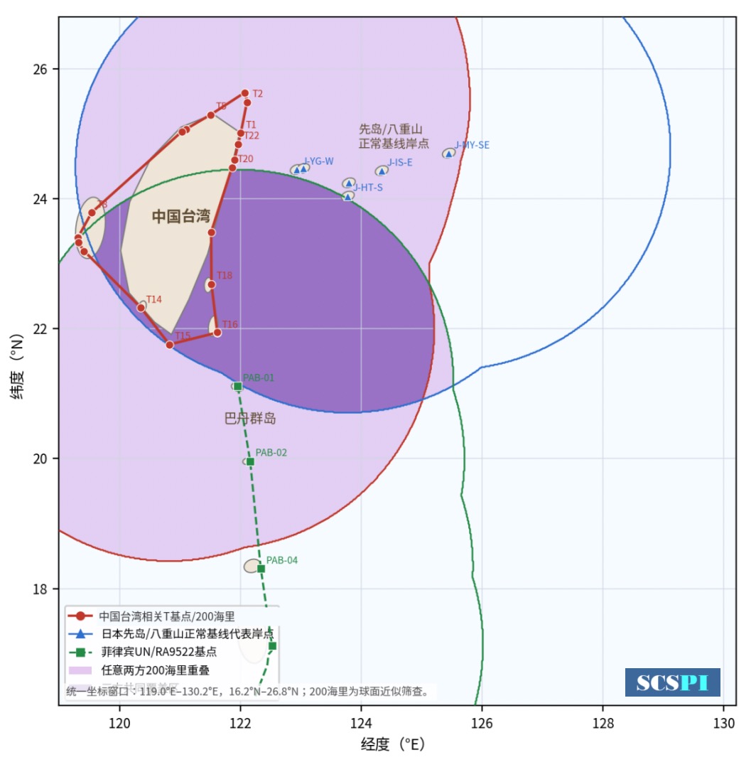
Figure 4. Map of the Overlapping 200-Nautical-Mile Zones East of Taiwan (Dark Purple Indicates the Overlap of the 200-Nautical-Mile Zones of China, Japan, and the Philippines) Source: Created by the author
II. Japan and the Philippines Have Not Demonstrated That the Contemplated Delimitation Area Is Separable from China’s Claims
In waters potentially subject to projections from more than two coasts, separability marks the outer boundary of bilateral disposition. Japan and the Philippines may only dispose of an area where their respective potential entitlements with legal basis overlap and is separable from third-party rights. That area cannot be determined simply by drawing two complete 200-nautical-mile arcs and treating their intersection as legally homogeneous. The relevant coasts, applicable baselines, the capacity of islands to generate maritime zones, and possible projections from third-party coasts all affect the outer limits of the two countries’ competence to effect a bilateral disposition.
President Marcos characterized the contemplated agreement as “essentially a matter between Japan and the Philippines.” As of the evidentiary cut-off date for this Article, however, materials made public by Japan and the Philippines disclosed none of the following: a map defining the negotiating area, the baselines to be used, controlling base points, proposed endpoints, or a mechanism safeguarding third-party rights.[10]
The information disclosed to date therefore indicates that Japan and the Philippines have not publicly established the complete factual foundation necessary to demonstrate separability. If they continued to exclude Beijing and proceeded to a final delimitation, they would not only breach international-law obligations of good faith, cooperation, and restraint, but could also infringe China’s maritime rights in waters east of Taiwan Island and potentially give rise to an internationally wrongful act.[11]
III. Prejudgments and Effects on Third-Party Positions and Interests
According to Reuters, Japanese Chief Cabinet Secretary Minoru Kihara stated that any maritime-boundary agreement reached by Japan and the Philippines would not be legally binding on third parties. Meanwhile, Philippine public statements emphasized that the negotiations would proceed in accordance with international law; President Marcos later characterized the contemplated agreement as essentially a bilateral matter between Japan and the Philippines.[12]
Article 34 of the Vienna Convention on the Law of Treaties provides that a treaty does not create either obligations or rights for a third State without its consent.[13] This rule addresses the issue of legal binding force: as a matter of law, a Japan–Philippines agreement cannot extinguish the rights of an absent party. However, it does not mean that the agreement cannot produce practical externalities. Maritime-boundary coordinates may be incorporated into official charts, fishing licences, resource blocks, coast-guard patrol instructions, and security-cooperation documents. Even if a third party is not legally bound by the agreement, it may nevertheless incur diplomatic, enforcement, and litigation costs in resisting those practical effects. International courts and tribunals employ approaches including open endpoints, formulas terminating a line before it reaches potential third-party interests, and non-prejudice safeguards precisely because formal non-opposability must be reinforced by self-restraint in both spatial scope and practical implementation.[14] Credible third-party protection must therefore operate on at least four levels: the treaty text must expressly preserve third-party rights; maps must leave potential tripartite areas undelimited; endpoints must remain open to future adjustment; and law-enforcement activity, resource licensing, and security cooperation must not treat an undelimited line as an exclusive boundary.
In international adjudication, where a court would have to determine, as a prerequisite, an absent country’s international responsibility or legal rights, and if that determination constitutes the very subject matter of the case, the Monetary Gold principle precludes the court from proceeding without that country’s consent.[15] Although the principle directly governs adjudicative proceedings, it offers a useful analogous screening criterion: a delimitation segment cannot become a purely bilateral matter merely through mutual consent between Japan and the Philippines.
IV. China Is Entitled to Make Diplomatic Representations and Protests and to Conduct Maritime Law-Enforcement Patrols in Relevant Waters
First, the stakeholder could ordinarily preserve its rights by making diplomatic representations and protests, requesting consultations, declining to recognize prejudicial coordinates, publicizing its positions, and collecting evidence. Second, it appears to be unexceptionable insofar as the China Coast Guard and China’s maritime authorities act in accordance with domestic law, conduct patrol and verification operations, carry out fisheries protection and rescue services, and maintain normal navigation and operational order while serving to reserve rights, establish facts, and perform jurisdictional functions relating to the relevant waters and subject matters.[16]
An American think tank contends that Beijing inspected hundreds of merchant vessels that showed no indication of engaging in resource development or causing damage to resources in the seabed or water column. [17] Such inspections infringed the rights of all countries using the area and interfered with commercial navigation. It accordingly accuses Beijing of violating UNCLOS and seeking to exercise broad and unprecedented jurisdiction over the area. Yet no evidence establishes that the patrol and verification activities conducted by Chinese maritime law-enforcement forces amounted to unlawful interception or disrupted normal commercial navigation.
V. Which Side Is Changing the Status Quo?
One view holds that China increased its survey vessels, maritime-administration activities, and the coast guard presence after Japan and the Philippines announced their delimitation negotiations, thereby seeking to change the status quo east of Taiwan through a quasi-routine maritime presence and jurisdictional assertions.[18] However, it must be emphasized that Japan and the Philippines characterized the undelimited waters east of Taiwan as a Japan–Philippines “bilateral matter” and advanced that process in parallel with defense cooperation without disclosing the scope of the contemplated delimitation area, demonstrating separability, or consulting China. They were thus the first to alter the pre-existing legal and procedural status quo, and their conduct was clearly provocative.
The security setting reinforces, but does not replace, that inference. Delimitation is advancing alongside arrangements for classified military information and transfers of maritime-defense assets, including destroyers scheduled for decommissioning. A line whose third-party limits remain unresolved could later organize patrols, surveillance, access expectations, or contingency planning affecting the Taiwan question. Parallel timing does not prove such a plan. It does make the risk foreseeable, and international objection need not await the moment when a disputed line has already hardened into operational practice.
Perpheps, the more pertinent questions are as follows: Why have Japan and the Philippines chosen this moment to advance maritime delimitation and defense cooperation in parallel? Why have they not disclosed a negotiating area and baseline assumptions sufficient to demonstrate separability? And why the haste to set a political objective of completing the negotiations within the year?[19] China’s protests, surveys, and patrols merely preserve its position and constitute reactive measures aimed at preventing Japan and the Philippines from transforming undelimited space into exclusive coordinates, licensing regimes, enforcement zones, or security boundaries.
VI. Unilateral Japan–Philippines Maritime Delimitation Is Highly Likely to Blur Their Respective Positions on the Taiwan Question
By pressing ahead with the negotiations without disclosing their scope or publicly communicating with Beijing, Japan and the Philippines risk further obscuring their respective positions on the Taiwan question. The fundamental reason is that maritime delimitation cannot avoid the antecedent questions of who owns Taiwan’s coasts and who is entitled to represent them. Nor can those questions be evaded merely by describing the process as a “bilateral matter.” Under the principle that “the land dominates the sea,” maritime entitlements derive from specific land-based coasts. Using base points located on Taiwan’s eastern coast, Orchid Island, or Green Island necessarily raises the question of which country they are taken to represent. Excluding those coasts altogether likewise entails a choice with implications for Taiwan policy.
In the 1972 China–Japan Joint Communique, Japan recognized the Government of the People’s Republic of China as the sole legal Government of China and stated that it “fully understands and respects” China’s position on Taiwan. Philippine Executive Order No. 313 of 1987 reaffirmed the relevant terms of the 1975 communique establishing diplomatic relations: the Government of the People’s Republic of China is the sole legal Government of China, there is but one China, and Taiwan is an integral part of Chinese territory.[20] Against this background, if Japan and the Philippines employ baselines promulgated by the Taiwan authorities without communicating with Beijing, their conduct may readily be understood as treating Taiwan as an independent coastal country capable of generating maritime entitlements. If they exclude Taiwan’s coasts entirely, their conduct may be understood as taking the position that those coasts cannot generate maritime entitlements for China. If they accept that those coasts belong to China but bypass Beijing, their conduct would sit uneasily with their recognition of Beijing as the sole legal Government of China. By neither disclosing the contemplated scope nor indicating which conception of the relevant parties and their legal status underpins their approach, Japan and the Philippines leave their Taiwan policies open to multiple interpretations.
In conclusion, the formal opening by Japan and the Philippines of negotiations to delimit exclusive economic zones and continental shelves in waters east of Taiwan has implications beyond the allocation of resources between neighbouring States; it may also affect the spatial order of key waters along the “First Island Chain.” The Joint Statement invokes UNCLOS and relevant international jurisprudence while simultaneously placing maritime delimitation, defense-related information sharing, and equipment transfers within the same partnership framework. This is sufficient to demonstrate a real risk that the contemplated boundary will be used for securitization purposes.[21]
Analyses of the issue should therefore neither accord the Japan–Philippines initiative a “presumption of legality” nor subject China’s response to a “most adverse strategic interpretation.” Objectively speaking, the decision by Japan and the Philippines to open delimitation negotiations at this juncture is unmistakably provocative and strategically inflammatory. That provocation should not be concealed by the rhetoric of “normal negotiations.” In the western Pacific, where maritime boundaries remain unsettled among multiple parties, any attempt to use legal characterization as a cover for political manipulation will undermine the region’s fragile maritime order.
Reference
[1]Japan–Philippines Joint Statement on the Comprehensive Strategic Partnership: “Weaving the Future Together: Peace, Prosperity, Possibilities” ¶¶ 2, 13 (May 28, 2026), https://www.mofa.go.jp/files/101035755.pdf; Presidential Communications Office, Philippines, President Marcos Concludes “Highly Productive, Constructive” State Visit to Japan (May 29, 2026), https://pco.gov.ph/news_releases/president-marcos-concludes-highly-produ....
[2]Japan–Philippines Joint Statement on the Comprehensive Strategic Partnership: “Weaving the Future Together: Peace, Prosperity, Possibilities” ¶¶ 4–5 (May 28, 2026), https://www.mofa.go.jp/files/101035755.pdf; Ministry of Defense, Japan, Japan–Philippines Defense Ministerial Meeting (Joint Press Statement) ¶¶ 2–3 (May 31, 2026), https://www.mod.go.jp/en/article/2026/05/45c008f13e32cdb63ef16520e4337fe....
[3]Ministry of Foreign Affairs of the People’s Republic of China, Foreign Ministry Spokesperson Mao Ning’s Regular Press Conference on June 2, 2026, https://www.mfa.gov.cn/fyrbt_673021/jzhsl_673025/202606/t20260602_11923344.shtml; Xinhua, Special Maritime Traffic Law-Enforcement Operation Launched in Waters East of Taiwan Island (June 6, 2026), https://www.news.cn/politics/20260606/ecf12ff0d4fd4ff5afc42983163a6c28/c.html; China Coast Guard, China Coast Guard Conducts Regular Law-Enforcement Patrols in Waters East of China’s Taiwan Island (July 4, 2026), https://www.ccg.gov.cn/hjyw/202607/t20260704_3129.html; Ministry of Foreign Affairs of the People’s Republic of China, Foreign Ministry Spokesperson Lin Jian’s Regular Press Conference on June 9, 2026, https://www.mfa.gov.cn/web/fyrbt_673021/jzhsl_673025/202606/t20260609_11940686.shtml.
[4]Presidential Communications Office, Philippines, Q&A with President Ferdinand R. Marcos Jr. at the Foreign Correspondents Association of the Philippines Presidential Luncheon (Aug. 14, 2026), https://pco.gov.ph/media-interview/qa-with-president-ferdinand-r-marcos-jr-at-the-foreign-correspondents-association-of-the-philippines-focap-presidential-luncheon/; Jiji Press, Philippines Eyes Concluding Sea Border Talks with Japan by Year-End, Nippon.com (Aug. 14, 2026), https://www.nippon.com/en/news/yjj2026081400669/; Asia Maritime Transparency Initiative, Center for Strategic and International Studies, As Tokyo and Manila Talk Boundaries, Beijing Breaks Them (Aug. 19, 2026), https://amti.csis.org/as-tokyo-and-manila-talk-boundaries-beijing-breaks-them/. The article characterizes the Japan–Philippines negotiations as a conventional bilateral delimitation exercise and assesses negatively the legality and purpose of certain Chinese maritime activities.
[5]North Sea Continental Shelf (Fed. Rep. Ger./Den.; Fed. Rep. Ger./Neth.), Judgment, I.C.J. Reports 1969, p. 3, at p. 51, ¶ 96 (Feb. 20), https://www.icj-cij.org/case/52; Maritime Delimitation in the Black Sea (Rom. v. Ukr.), Judgment, I.C.J. Reports 2009, p. 61, at p. 89, ¶ 77 (Feb. 3), https://www.icj-cij.org/case/132.
[6]Michael Sheng-ti Gau & Hsien-Wen Huang, An Analysis of the International Legal Issues Raised by the Japan–Philippines Maritime Delimitation Negotiations, China Review, July 2026, no. 343, pp. 20–23 (Chinese).
[7]Taiwan proper and its 21 affiliated islands have an area of 35,887.1325 square kilometres, https://www.ey.gov.tw/state/4447F4A951A1EC45/094b1d53-de8d-4393-bde6-ab092969cce4; as of July 2026, Taiwan’s population was 23,235,002, https://eng.stat.gov.tw/Point.aspx?n=4208&sid=t.9&sms=11713. Okinawa Prefecture, Department of Planning, Regional and Remote Islands Division, 2025 Materials Relating to Remote Islands, ch. 1, p. 2, https://www.pref.okinawa.jp/_res/projects/default_project/_page_/001/033/624/01_chapter1_r7.pdf (the inhabited islands of Miyako and Yaeyama have a combined area of 806.68 square kilometres and a basic-resident-registry population of 107,244); Philippine Statistics Authority, Province of Batanes, https://psa.gov.ph/classification/psgc/citimuni/0200900000 (2024 population: 18,937); Department of Budget and Management, Philippines, FY 2014 Internal Revenue Allotment for LGUs: Region II, https://www.dbm.gov.ph/wp-content/uploads/Issuances/IRA/IRA2014/PCM/RO2/RO2.pdf (Batanes Province has an area of 219.01 square kilometres). Using statistics drawn from different years and compiled under different methodologies solely for an order-of-magnitude comparison, the land area of Taiwan proper and its affiliated islands is approximately 44 times that of the inhabited Miyako and Yaeyama islands combined and 164 times that of Batanes Province; Taiwan’s population is approximately 217 times that of the former and 1,227 times that of the latter. Land area and population do not automatically determine maritime entitlements or delimitation ratios; the comparison merely demonstrates that the potentially affected coastal frontage cannot be disregarded.
[8]Territorial and Maritime Dispute (Nicar. v. Colom.), Application by Costa Rica for Permission to Intervene, Judgment, I.C.J. Reports 2011, p. 348, at pp. 372–73, ¶¶ 86–90 (May 4), https://www.icj-cij.org/case/124/intervention; Delimitation of the Maritime Boundary in the Bay of Bengal (Bangl./Myan.), Judgment, ITLOS Reports 2012, p. 4, ¶¶ 462, 505, dispositif para. 6 (Mar. 14), https://www.itlos.org/en/main/cases/list-of-cases/case-no-16/.
[9]United Nations Convention on the Law of the Sea art. 76(1), (4)–(7), Dec. 10, 1982, 1833 U.N.T.S. 3, https://www.un.org/depts/los/convention_agreements/texts/unclos/unclos_e....
[10]Japan–Philippines Joint Statement on the Comprehensive Strategic Partnership: “Weaving the Future Together: Peace, Prosperity, Possibilities” ¶ 13 (May 28, 2026), https://www.mofa.go.jp/files/101035755.pdf; Presidential Communications Office, Philippines, Q&A with President Ferdinand R. Marcos Jr. at the Foreign Correspondents Association of the Philippines Presidential Luncheon (Aug. 14, 2026), https://pco.gov.ph/media-interview/qa-with-president-ferdinand-r-marcos-....
[11]United Nations Convention on the Law of the Sea arts. 74(1), 74(3), 83(1), 83(3), 300, Dec. 10, 1982, 1833 U.N.T.S. 3, https://www.un.org/depts/los/convention_agreements/texts/unclos/unclos_e.pdf; North Sea Continental Shelf (Fed. Rep. Ger./Den.; Fed. Rep. Ger./Neth.), Judgment, I.C.J. Reports 1969, p. 3, at p. 47, ¶ 85 (Feb. 20), https://www.icj-cij.org/case/52; Delimitation of the Maritime Boundary Between Guyana and Suriname, Award, 30 R.I.A.A. 1, ¶¶ 459–70 (Sept. 17, 2007), https://legal.un.org/riaa/cases/vol_XXX/1-144.pdf. These rules support scrutiny of the duty to negotiate in good faith and of conduct that might jeopardize or hamper a final agreement.
[12]Reuters, Taiwan Says Japan, Philippines Must Respect Its Rights in Maritime Border Talks (June 3, 2026), reproduced by Internazionale, https://www.internazionale.it/ultime-notizie-reuters/2026/06/03/taiwan-s... Japan–Philippines Joint Statement on the Comprehensive Strategic Partnership: “Weaving the Future Together: Peace, Prosperity, Possibilities” ¶ 13 (May 28, 2026), https://www.mofa.go.jp/files/101035755.pdf; Presidential Communications Office, Philippines, Q&A with President Ferdinand R. Marcos Jr. at the Foreign Correspondents Association of the Philippines Presidential Luncheon (Aug. 14, 2026), https://pco.gov.ph/media-interview/qa-with-president-ferdinand-r-marcos-....
[13]Vienna Convention on the Law of Treaties art. 34, May 23, 1969, 1155 U.N.T.S. 331, https://legal.un.org/ilc/texts/instruments/english/conventions/1_1_1969.pdf.
[14]Territorial and Maritime Dispute (Nicar. v. Colom.), Application by Costa Rica for Permission to Intervene, Judgment, I.C.J. Reports 2011, p. 348, at pp. 372–73, ¶¶ 86–90 (May 4), https://www.icj-cij.org/case/124/intervention; Delimitation of the Maritime Boundary in the Bay of Bengal (Bangl./Myan.), Judgment, ITLOS Reports 2012, p. 4, ¶¶ 462, 505, dispositif para. 6 (Mar. 14), https://www.itlos.org/en/main/cases/list-of-cases/case-no-16/.
[15]Monetary Gold Removed from Rome in 1943 (It. v. Fr., U.K. & U.S.), Judgment, I.C.J. Reports 1954, p. 19, at p. 32 (June 15), https://www.icj-cij.org/case/19; cf. Land and Maritime Boundary Between Cameroon and Nigeria (Cameroon v. Nigeria: Eq. Guinea Intervening), Judgment, I.C.J. Reports 2002, p. 303, at pp. 421–22, ¶¶ 237–38 (Oct. 10), https://www.icj-cij.org/case/94 (the Court may address the boundary between the parties but may not determine the boundary between a party and a third State).
[16]China Coast Guard, China Coast Guard Conducts Regular Law-Enforcement Patrols in Waters East of China’s Taiwan Island (July 4, 2026), https://www.ccg.gov.cn/hjyw/202607/t20260704_3129.html; Xinhua, Special Maritime Traffic Law-Enforcement Operation in Waters East of Taiwan Island Successfully Concluded (June 10, 2026), https://www.news.cn/20260610/ff588669dd7b418989e55f6dc7f45fd0/c.html; Ministry of Foreign Affairs of the People’s Republic of China, Foreign Ministry Spokesperson Lin Jian’s Regular Press Conference on June 9, 2026, https://www.mfa.gov.cn/web/fyrbt_673021/jzhsl_673025/202606/t20260609_11940686.shtml.
[17]Asia Maritime Transparency Initiative, Center for Strategic and International Studies, As Tokyo and Manila Talk Boundaries, Beijing Breaks Them (Aug. 19, 2026), https://amti.csis.org/as-tokyo-and-manila-talk-boundaries-beijing-breaks-them/. The article argues that China’s inspection of merchant vessels not engaged in resource activities interfered with freedom of navigation and sought to establish excessively broad jurisdiction.
[18]Asia Maritime Transparency Initiative, Center for Strategic and International Studies, As Tokyo and Manila Talk Boundaries, Beijing Breaks Them (Aug. 19, 2026), https://amti.csis.org/as-tokyo-and-manila-talk-boundaries-beijing-breaks-them/. The article argues that, after Japan and the Philippines announced the delimitation negotiations, China increased the activities of survey vessels, maritime-administration authorities, and the coast guard in an attempt to establish a “new status quo” in waters east of Taiwan through a quasi-routine maritime presence and assertions of jurisdiction.
[19]Japan–Philippines Joint Statement on the Comprehensive Strategic Partnership: “Weaving the Future Together: Peace, Prosperity, Possibilities” ¶¶ 4–5, 13 (May 28, 2026), https://www.mofa.go.jp/files/101035755.pdf; Ministry of Defense, Japan, Japan–Philippines Defense Ministerial Meeting (Joint Press Statement) ¶¶ 2–3 (May 31, 2026), https://www.mod.go.jp/en/article/2026/05/45c008f13e32cdb63ef16520e4337fe....
[20]Joint Communique of the Government of Japan and the People’s Republic of China ¶¶ 2–3 (Sept. 29, 1972), https://www.mofa.go.jp/region/asia-paci/china/joint72.html; Philippines, Executive Order No. 313 (Dec. 17, 1987), https://elibrary.judiciary.gov.ph/thebookshelf/showdocs/5/6398 (reproducing the language of the June 9, 1975 Joint Communique establishing China–Philippines diplomatic relations).
[21]Japan–Philippines Joint Statement on the Comprehensive Strategic Partnership: “Weaving the Future Together: Peace, Prosperity, Possibilities” ¶¶ 4–5, 13 (May 28, 2026), https://www.mofa.go.jp/files/101035755.pdf; Ministry of Defense, Japan, Japan–Philippines Defense Ministerial Meeting (Joint Press Statement) ¶¶ 2–3 (May 31, 2026), https://www.mod.go.jp/en/article/2026/05/45c008f13e32cdb63ef16520e4337fe....
Zheng Zhihua

Dr. ZHENG Zhihua is an associate Professor of Japan Research Center of Shanghai Jiaotong University, and Head of East Asia Marine Policy Project. He is currently a visiting scholar at the Huayang Centre for Maritime Cooperation and Ocean Governance in Haikou. He is also a member of the Professional Committee of Maritime History and Culture Research of the China Maritime Society. He severed as the director of Joint Institute for Maritime Law and History, assistant dean of the School of International Shipping Law at East China University of Political Science and Law (ECUPL), and deputy secretary general of Shanghai Law and Society Association. He joined the board of editorial of China Ocean Law Review and severed as senior editor from 2010 to 2013. He was appointed as Judge of Ningbo Maritime Court in 2004. He got qualification for admission to the Chinese Bar in 1998. He was a visiting fellow of St. John’s College at Oxford University, Institute of Maritime Law at Southampton University and Law Faculty at Göettingen University.