The Spratly Islands sits in the southern part of the South China Sea, stretching from Marie Louise Bank in the north to James Shoal in the south, bordered by Vanguard Bank to the west and Seahorse Shoal to the east. It is China’s southernmost archipelago, comprising over 200 features of islands, reefs, shoals and sandbars. Six parties—China, Vietnam, the Philippines, Malaysia, Brunei and Chinese Taiwan—have made claims to all or part of the islands, with Vietnam occupying 29 features in total. Since the 1970s, Vietnam has continuously carried out reclamation activities on relevant features. A new wave of expansion projects has been witnessed after October 2021.
I. Rapid Reclamation Progress
According to the comparison of remote sensing images, Vietnam has initiated a new round of large-scale reclamation on its illegally occupied Spratly features since October 2021. These activities involve 11 features: Namyit Island, Sand Cay, Tennent Reef, Pearson Reef, Barque Canada Reef, Alison Reef, Cornwallis South Reef, Ladd Reef, Discovery Great Reef, Central Reef and South Reef. As of May 2025, Vietnam has reclaimed over 8.5 km² of land across these features.
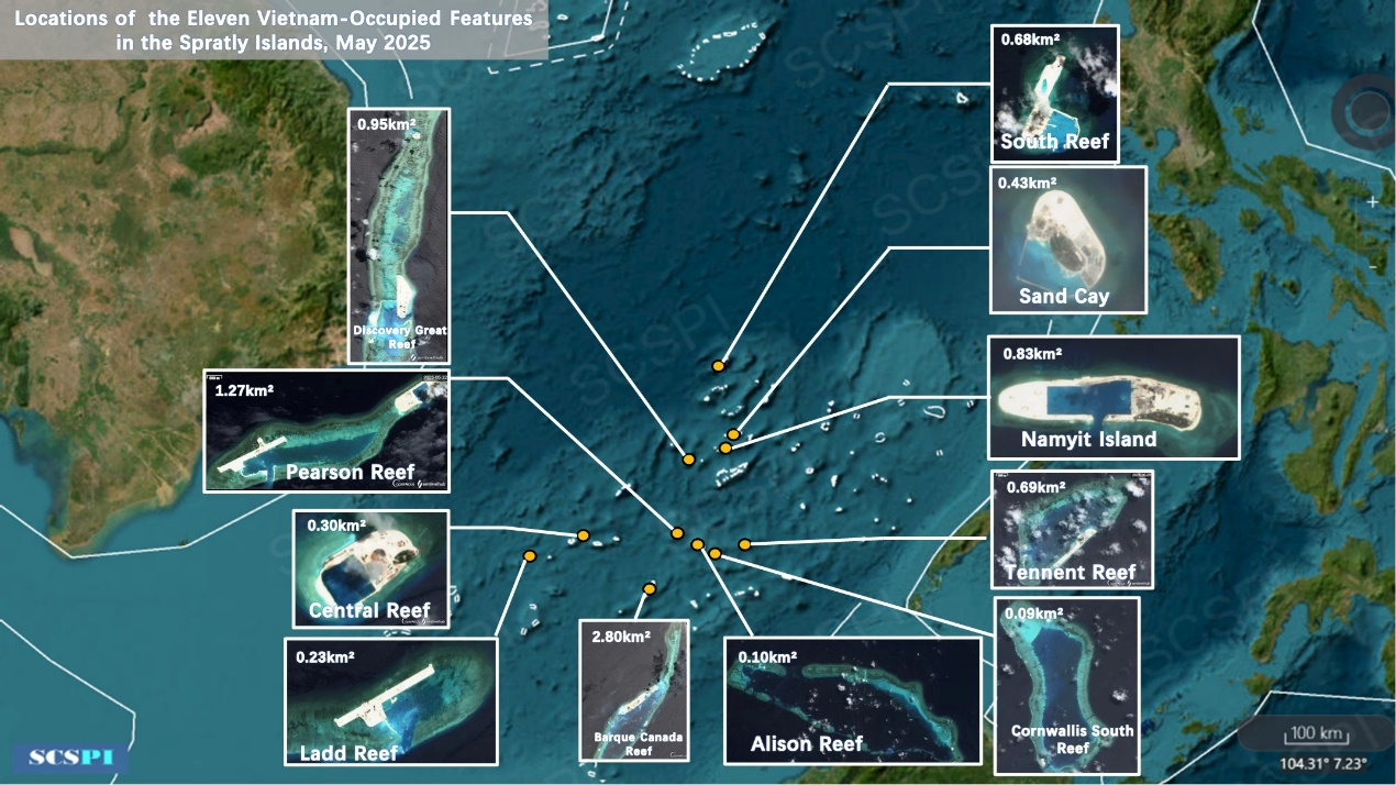
Figure 1: Locations of 11 Vietnam-occupied Features
In this round of expansion, Vietnam has deployed cutter suction dredgers for the first time. In May 2022, Dutch shipbuilding company Royal IHC delivered a Beaver 65 cutter suction dredger to the Vietnamese company DACINCO. In June 2023, Royal IHC delivered the second Beaver 65 to DACINCO and signed a contract for the third one. In November 2022, Royal IHC delivered 2 more dredgers—a Beaver 70 and a Beaver 45—to the Xuan Thien Group. In July 2024, Royal IHC signed an agreement with Nam Trieu Shipyard to construct a trailing suction hopper dredger in Asia, marking the first IHC dredger built by Vietnam. These dredgers have been extensively used in the reclamation of Namyit Island, Pearson Reef and Barque Canada Reef, significantly enhancing Vietnam’s efficiency.
Namyit Island is located in the southern part of Tizard Bank, about 15 nautical miles north of Itu Aba Island. It is an oval-shaped sandbar, originally covering an area of approximately 0.08 km². In October 2021, Vietnam began dredging and backfilling on the sandbar. From 2022 to 2023, reclamation extended northward and westward, with the southern seawall forming a preliminary harbor framework. By 2024, the harbor was nearly complete, measuring about 980 meters long and 400 meters wide. As of May 2025, Vietnam has reclaimed a total land area of 0.83 km² on Namyit Island.
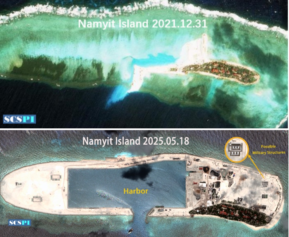
Figure 2: Remote Sensing Images of Namyit Island
Sand Cay lies about 6.3 nautical miles east of Itu Aba Island and 18 nautical miles west of Gaven Reef. It is an oval-shaped sandbar with an original area of approximately 0.09 km². In October 2021, Vietnam began dredging and backfilling. From 2022 to 2024, Vietnam built a harbor framework on the southwest side and expanded reclamation to the northern part of the sandbar. By May 2025, land reclamation on the northern and eastern sides was nearly complete, while the southwest harbor framework was taking shape. The total land area of Sand Cay is now approximately 0.43 km².

Figure 3: Remote Sensing Images of Sand Cay
Located northeast of Amboyna Cay, Pearson Reef is a small atoll measuring about 9 km in length and 2 km in width with a small sandbar at the northeastern end and a fortified outpost on the northwest side. In October 2021, Vietnam began dredging and backfilling on the northeastern sandbar, using small cutter suction dredgers for efficiency. By 2022, a preliminary harbor was constructed, measuring 530 meters long and 410 meters wide, with further reclamation continuing on its southwest side. From 2023 to 2024, Vietnam expanded reclamation around the northwest outpost, forming a landmass approximately 2,500 meters long and 180 meters wide. As of May 2025, the total land area of Pearson Reef is approximately 1.27 km².
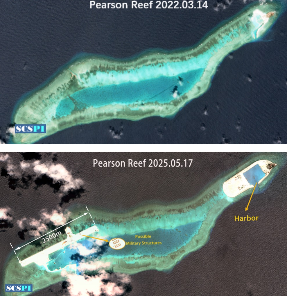
Figure 4: Remote Sensing Images of Pearson Reef
Tennent Reef is a triangular atoll located 100 km south of the Union Banks, with a military outpost on the western side and a lighthouse on the eastern side. Vietnam began dredging and backfilling here in December 2021, excavating a lagoon channel on the southeastern atoll and conducting land reclamation projects. By 2022, the lagoon channel on the southeastern sandbar had been preliminarily completed, forming a landmass approximately 920 meters long and 210 meters wide. In 2024, reclamation around two bunkers on the western side was launched, creating a 3,770-meter-long landmass that connected with the southeastern reclamation. As of May 2025, Tennent Reef’s total land area is approximately 0.69 km².
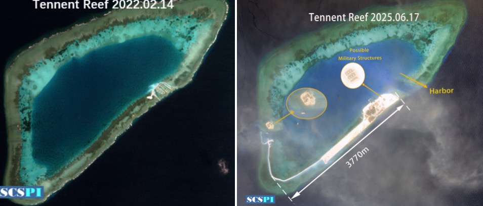
Figure 5: Remote Sensing Images of Tennent Reef
Barque Canada Reef, located in the southern part of the Spratly Islands, holds the largest reef flat among all Spratly features. Vietnam has established 3 military outposts on this atoll, set on the central western end, southwestern end and the northernmost part of the reef. In December 2021, Vietnam began dredging and backfilling on the southeastern atoll, excavating lagoon channels and reclaiming land. By 2022, the lagoon channel on the eastern side was mostly formed. From 2023 to 2024, small cutter suction dredgers were deployed in the northwest construction area. The reclamation was significantly accelerated, accomplishing the construction of a 4,300-meter-long sandbar and the commencement of an airstrip. By May 2025, the airstrip was taking shape, and the total reclaimed land area on Barque Canada Reef reached approximately 2.8 km².
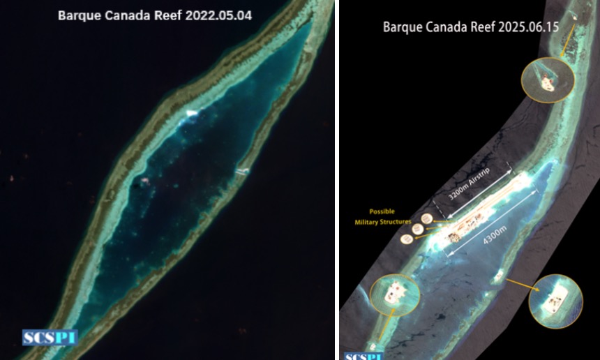
Figure 6: Remote Sensing Images of Barque Canada Reef
Discovery Great Reef, located between Gaven Reef and Fiery Cross Reef, is a strip-shaped atoll with 3 military outposts located on its southeastern, southwestern and northern sides. In October 2022, Vietnam began a new round of reclamation on Discovery Great Reef, expanding land around the southwestern and southeastern outposts. In October 2023, reclamation began around the northern outpost. By May 2025, small sandbars had been formed on the southwestern, eastern and northern sides, with a total land area of approximately 0.95 km².
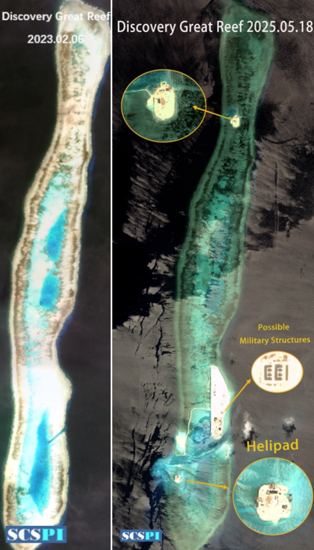
Figure 7: Remote Sensing Images of Discovery Great Reef
Cornwallis South Reef is a relatively enclosed atoll lying approximately 6 nautical miles southeast of Gaven Reef. Vietnam has 2 military outposts on the reef, located on the southwestern and northern ends, as well as rectangular platform foundations on the southwestern and eastern sides. In October 2022, Vietnam initiated a new round of reclamation, expanding land around the southwestern and eastern platform foundations. By 2023, a lagoon channel was excavated near the western outpost, and in December 2024, a new phase of expansion started at the northern outpost. As of May 2025, Cornwallis South Reef’s total land area is approximately 0.09 km².
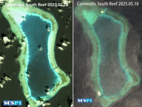
Figure 8: Remote Sensing Images of Cornwallis South Reef
Located 13 nautical miles west of Spratly Island, Ladd Reef is a strip-shaped small atoll with 2 bunker-style outposts on its central northern side. In October 2022, Vietnam began a new round of reclamation on Ladd Reef. From 2023 to 2024, Vietnam expanded eastward and westward from 2 bunkers, creating a 2,430-meter-long and 180-meter-wide sandbar. As of May 2025, the total land area of Ladd Reef is approximately 0.6 km².
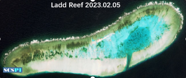
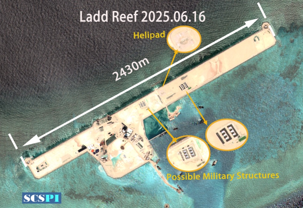
Figure 9: Remote Sensing Images of Ladd Reef
Alison Reef, an oval-shaped atoll seated about 12 nautical miles southeast of Pearson Reef, has 3 military outposts on the eastern, western and northern sides. In December 2022, Vietnam began expanding sandbars around the southwestern outpost. In September 2024, land reclamation started around the northern and northwestern outposts. As of May 2025, the total land area of Alison Reef is approximately 0.1 km².
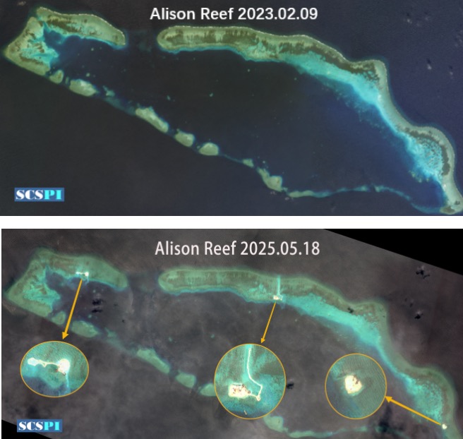
Figure 10: Remote Sensing Images of Alison Reef
Central Reef is located in the middle of London Reefs, approximately 5 nautical miles northeast of West Reef. In 2012, Vietnam conducted land reclamation on the eastern sandbar of Central Reef, creating a landmass of approximately 0.02 km². Starting in October 2023, Vietnam launched a new wave of expansion. By May 2025, a harbor measuring approximately 400 meters long and 380 meters wide had been constructed, bringing the total land area of Central Reef to about 0.3 km².
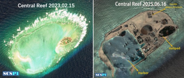
Figure 11: Remote Sensing Images of Central Reef
South Reef, situated at the southwestern end of the North Danger Reefs, has constructed 2 multi-story bunkers on its northern-central part. From October 2023, Vietnam began a new round of reclamation around the bunkers. By October 2024, a sandbar approximately 1,940 meters long had been extended northward, with a harbor framework forming on the northeastern side. As of May 2025, the total land area of South Reef reached approximately 0.68 km².
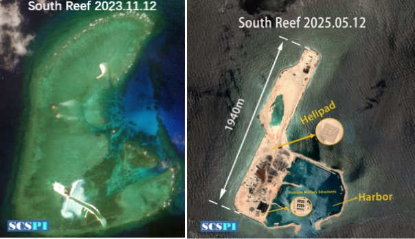
Figure 12: Remote Sensing Images of South Reef
II. The Construction of Military Facilities Accelerated
In addition to ongoing reclamation, Vietnam has begun constructing related buildings and facilities, entering a stage of simultaneous expansion and construction. This round of expansion not only focuses on increasing land area for outposts but also on building harbors, docks, runways and other military facilities aimed at enhancing Vietnam’s military projection and rapid response capabilities in the South China Sea.
In July 2023, The Manila Times reported that the Vietnamese government had planned 34 projects to strengthen the infrastructure and armaments on its occupied features. These projects include varying degrees of reclamation at Pearson Reef, Tennent Reef and Barque Canada Reef, along with the construction of “bunkers, command posts, firepower positions, weapon storage facilities, trench systems and tactical facilities.” Additionally, Vietnam plans to build a 180-meter-long port at Sand Cay to accommodate its Gepard 3.9-class frigates, along with defensive structures, combat bunkers and barracks. 2 additional ports are also planned for Namyit Island to dock the frigates.[1]
2.1 Harbors and Docks
Prior to 2021, Vietnam had harbors only at Spratly Island, Southwest Cay, Sin Cowe Island and West Reef. Among the 11 occupied features undergoing expansion in this round, harbors capable of accommodating large vessels have been built or are under construction on 8 features: Namyit Island, Sand Cay, Pearson Reef, Tennent Reef, Barque Canada Reef, Ladd Reef, South Reef and Central Reef.
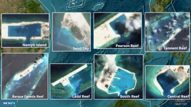
Figure 13: Image of harbors on 8 Vietnam-occupied Features
2.2 Runways and Airfields
Before 2021, among Vietnam-occupied features in the Spratly Islands, only Spratly Island had a runway of approximately 1,200 meters, which was insufficient for large military transport aircraft, reconnaissance planes or bombers. In this round of reclamation, apart from Barque Canada Reef, Vietnam has extended sandbars ranging from 1,900 meters to 4,300 meters with sufficient length for runways at Ladd Reef, Pearson Reef, Tennent Reef and South Reef. Upon completion, Vietnam may possess 5 to 6 runways in the Spratly Islands, giving it with a geographic advantage over other claimants including China.
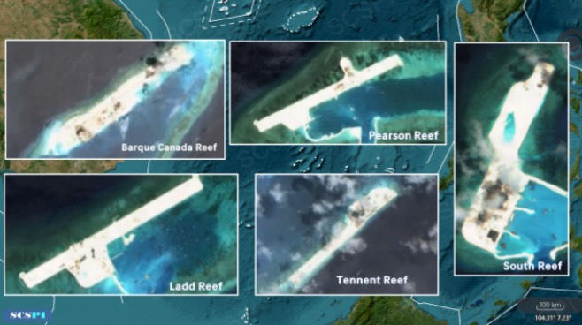
Figure 14: Image of Sandbars on 5 Vietnam-occupied Features
2.3 Coastal Defense Facilities
This round of expansion has seen rapid progress, with new coastal defense facilities emerging alongside the construction of harbors and runways. Temporary helipads have been added to Tennent Reef, Discovery Great Reef, Ladd Reef and South Reef. Additionally, new berms have been built on Barque Canada Reef, Central Reef, Tennent Reef, Namyit Island and South Reef. Given the coastal nature of these features, it is anticipated that anti-ship artillery or missile platforms could be deployed in these areas.
Vietnam’s current wave of reclamation is unprecedented in scale and speed, constructing military facilities on various features. Although the pace has slowed, there are no signs of cessation, especially with expansions at Cornwallis South Reef, Alison Reef and Central Reef likely still in their early stages. Based on Vietnam’s ambitions since the 1970s and the current state of construction, it is plausible that Vietnam ultimately aims to surpass other claimants, including China, in terms of reclaimed land area in the Spratly Islands. With the growing economy and national power in recent years, Vietnam may also revise its original plans to pursue even larger-scale expansions in the region.
Evidence suggests that Vietnam is attempting to connect its occupied features into a cohesive network, forming a complete operational system to enhance its military presence and deterrence capabilities in the South China Sea. This round of expansion has set new records in terms of scale, technology, and speed, triggering widespread international concern.
For over a decade, Western countries, including the US, have primarily focused their South China Sea narratives on China due to great power competition, ideological biases and sympathy for the underdog, while deliberately downplaying or ignoring the aggressive actions of Vietnam and the Philippines. However, this time, even Western think tanks and media outlets, such as AMTI, Reuters and Radio Free Asia, have begun criticizing Vietnam’s island-building activities. Despite Vietnam’s efforts to remain low-key, its expansion and militarization of Spratly features have become a significant event impacting peace and stability in the South China Sea and the development of regional rules and orders.
Reference
[1] Vietnam beefs up militarization in WPS, The Manila Times, July 16, 2023, https://www.manilatimes.net/2023/07/16/news/vietnam-beefs-up-militarizat...
SCSPI

With a view to maintaining and promoting the peace, stability and prosperity of the South China Sea, we launched the South China Sea Strategic Situation Probing Initiative (SCSPI) in April of 2019. The Initiative aims to integrate intellectual resources and open source information worldwide and keep track of important actions and major policy changes of key stakeholders and other parties involved. It will provide professional data services and analysis reports to parties concerned, helping them keep competition under control, and with a view to seek partnerships.