The South China Sea, situated at the crossroads of major East-West shipping routes in the western Pacific, spans approximately 3.5 million square kilometers. It serves as a vital maritime artery, carrying around one-third of the world’s seaborne trade and 40% of global oil and petroleum product shipments. However, the region poses substantial navigational challenges due to its complex geography: densely clustered islands, reefs, and shoals, along with submerged rocks and shallow banks, create a hazardous seascape. These risks are further compounded by frequent adverse weather conditions, including typhoons, sea fog, and tsunamis, that pose serious threats to safe navigation.
Moreover, significant disparities in economic development and governance capacity exist among the coastal states surrounding the South China Sea. The region’s maritime safety infrastructure remains fragmented, with limited communication, navigation, and search and rescue capabilities, as well as little centralized coordination. In addition, the area continues to be a global hotspot for maritime piracy and armed robbery against ships, particularly near the Strait of Malacca and Singapore Strait, where over 50 incidents were reported in the first half of 2025.
As the largest coastal state bordering the South China Sea, China has consistently acted as a responsible major country. It is committed to safeguarding maritime safety in the region by actively contributing to navigational safety, disaster prevention and mitigation, maritime search and rescue, and crime suppression. Through these efforts, China continues to provide an expanding array of maritime public security services to both the region and the broader international community.
Providing Intelligent Navigation Support
China has been a Category A member of the International Maritime Organization (IMO) since 1989. Recognizing the strategic significance of the South China Sea as a major international shipping route, China consistently enhances navigation services through intelligent and digital solutions, providing essential public safety infrastructure for global maritime traffic.
Firstly, China has systematically established intelligent navigational aids. As of June 2025, it had installed 95 navigational facilities across the South China Sea, including lighthouses, beacons, leading marks, floating buoys, and shore-based Automatic Identification System (AIS) stations, transitioning from point-based to comprehensive coverage. In Sansha, navigation facilities have achieved 100% remote management via BeiDou satellite terminals. Two Beidou-based AIS shore stations at Beijiao Reef and Langhua Reef, both located along key international shipping lanes, leverage BeiDou’s combined communication and navigation capabilities to provide real-time vessel data—position, speed, heading and identification. This integrated system enables precise navigation, rapid emergency response, and smart maintenance.[1] Specifically, BeiDou’s full coverage allows maritime authorities to continuously track vessel positions and dynamics, ensuring reliable navigation services. In emergencies such as groundings or fires, BeiDou’s real-time monitoring of nearby vessels significantly shortens rescue response times, improving emergency rescue capabilities and minimizing casualties and property losses. Furthermore, the BeiDou-based telemetry and remote-control system ensures constant monitoring of navigational aids, promptly detecting malfunctions, improving offshore maintenance, and supporting stable long-term operation.

Figure 1: BeiDou Navigation Satellite System
Secondly, China has deployed fullly electric intelligent buoy tenders. In November 2024, the South China Sea Navigation Support Center launched “Haixun 176”, a fully electric buoy tender. Measuring 75.2 meters in length, 14 meters in width, with a displacement of approximately 2,450 tons, it has a range of 5,000 nautical miles and an endurance of 40 days. Capable of safely navigating in Sea State 6 and conducting operations in Sea State 4, the “Haixun 176” primarily deploys and maintains navigational aids across the South China Sea. It also supports oil spill response, maritime emergency rescue, personnel transportation, and logistical supply, significantly enhancing navigational safety services and emergency response capabilities in the region.[2]
Thirdly, China has integrated intelligent maritime service platforms. The South China Sea Navigation Support Center, under China’s Ministry of Transport, developed a public service mobile application known as “Qihangzhe” (iSailing), in alignment with the IMO’s e-navigation framework and standards. Supported by authoritative global data, the app integrates comprehensive navigational information and offers intelligent services, including route planning, navigation regulations guidance, and collision avoidance recommendations. It delivers real-time hydrological and meteorological updates—such as tides, wind speed and direction, and visibility—and provides precise early warnings for typhoons, sea fog, and tsunamis. The app also generates disaster-avoidance route plans based on historical sea conditions and geographical data, thus forming a complete risk management and disaster mitigation safety system spanning “risk monitoring–warning issuance–hazard avoidance routes”.
Enhancing Disaster Preparedness and Mitigation
Since the establishment of the Xisha Meteorological Station (predecessor of the Sansha Station) on July 1, 1957, China has maintained continuous meteorological observations in the South China Sea, accumulating over 60 years of uninterrupted baseline data.[3] Currently, under the leadership of the South China Sea Marine Forecasting and Disaster Mitigation Center of the Ministry of Natural Resources, China has developed a comprehensive maritime disaster prevention and mitigation system that integrates multi-dimensional monitoring, intelligent early warning, and regional collaboration.
First, China has established a multi-dimensional monitoring and forecasting system. In satellite-based observation, China’s independently developed FengYun meteorological satellites and high-resolution remote sensing satellites provide continuous, real-time tracking of typhoon formation and trajectories, sea fog distribution, and tsunami dynamics in the South China Sea.[4] In November 2023 and September 2024, the China Meteorological Administration released the international and ASEAN editions of “FengYun Earth” platform, respectively, providing public meteorological products and services to the international community. As of November 2024, FengYun satellites had served 132 countries and regions, with 36 countries and regions registered under the Emergency Support Mechanism for International Users of FengYun Meteorological Satellites in Disaster Prevention and Mitigation. Since the mechanism was first activated in September 2018, it has responded to over 100 international requests for emergency assistance.[5] On land and sea, the meteorological observation system for the Nansha Islands is fully operational, achieving 100% monitoring coverage of severe weather events such as typhoons, heavy rain, and thunderstorms. AI-driven smart forecasting grids deliver integrated land-sea forecasts, with spatial resolutions of 1 kilometer and temporal resolutions of 1 hour, extending forecasting up to 10 days.

Figure 2: FY-3 Polar-orbiting Meteorological Satellite
Second, China has significantly enhanced its intelligent disaster early warning capabilities. Its tsunami early warning buoy system, deployed in the South China Sea, detects seismic activities in three fault zones north of the Manila Trench within 15 to 45 minutes. This provides coastal cities a warning lead time of 2 to 5 hours, effectively strengthening tsunami monitoring and early warning capacities.[6] The “Integrated Marine Meteorological Monitoring Platform”, developed by China’s South China Sea Meteorological Disaster Prevention and Mitigation Laboratory, has significantly upgraded forecasting and alert systems by delivering comprehensive, targeted SMS alerts to fishermen. In May 2023, China’s self-developed global storm surge and tsunami monitoring and early warning system officially commenced operations, providing real-time tidal data from over 300 monitoring stations across 65 coastal countries.[7]
Third, China actively promotes regional cooperation and technology sharing. The South China Sea Regional Tsunami Advisory Center, led by China, provides continuous tsunami monitoring and early warning services to nine surrounding countries, including Brunei, Cambodia, Indonesia, Malaysia, the Philippines, Singapore, Thailand, Vietnam, and China itself. The center also regional technical exchanges and standardized tsunami early warning training. Since 2018, it has trained over 300 international participants and hosted over ten short-term staff exchanges. In April 2025, China hosted the 31st session of the UNESCO Intergovernmental Coordination Group for the Pacific Tsunami Warning and Mitigation System (ICG/PTWS), facilitating international sharing of tsunami monitoring, forecasting, and disaster mitigation technologies and experiences.[8] Additionally, China’s independently developed ocean numerical forecasting models—“Mazu Current” and “Mazu Wave”—have been operational since 2021 and 2023 respectively. These models have played a key role in marine disaster emergency forecasting during typhoons such as “Yagi” and “Gaemi”. In December 2024, the source code of the Mazu series ocean forecasting models was officially released as open-source internationally.[9]
Building an Integrated Sea-Air Search and Rescue System
China’s maritime rescue forces serve as the final safeguard of maritime safety, operating in strict accordance with the International Convention on Maritime Search and Rescue. In the South China Sea, China has developed a comprehensive sea-air emergency rescue system that systematically provides humanitarian public goods to the international community. This plays a crucial role in protecting lives and property, and in ensuring the stability of maritime logistics and supply chains in the region.
First, China has established a robust “three-in-one” sea-air rescue network. China Rescue and Salvage (CRS), founded in 1951, has grown over the past seven decades from humble beginnings into a vital force in maritime rescue and salvage. It has played an indispensable role in operations across the South China Sea. One notable example occurred on November 22, 2007, when tropical storm “Hagibis” struck, leaving dozens of Chinese and foreign fishing vessels and over a thousand fishermen stranded in the Xisha and Nansha Islands. With the situation rapidly deteriorating, CRS deployed three rescue ships and a helicopter to the affected areas. Over eight days, CRS successfully rescued 52 Chinese fishing boats and 1,022 fishermen, including 7 Vietnamese and 29 Filipino nationals.[10]
Since China’s professional rescue forces officially entered the Nansha Islands in July 2018, an integrated rescue system encompassing aerial search and rescue, rapid surface response, and underwater salvage operations has gradually taken shape. By April 15, 2025, Chinese rescue forces had completed 28 rotations of rescue vessels and 11 rotations of rescue helicopters for emergency standby in the Nansha Islands, deploying a total of 850 personnel. They carried out 119 rescue missions, successfully rescuing 704 individuals and assisting 30 distressed vessels, with recovered property valued at over RMB 4.186 billion.[11]
Second, China has significantly upgraded its deep-sea and far-sea rescue capabilities. With the advancement of China’s marine science and technology—especially in deep-sea equipment—its capability to conduct rescue operations in deep and distant waters has grown rapidly. In January 2024, the domestically designed and constructed “Nanhai Rescue 103” vessel was officially commissioned. With a full-load displacement of 19,000 tons and a range of 16,000 nautical miles, it is equipped for surface search and rescue, deep-sea towing, and coordinated sea-air operations. Capable of carrying large rescue helicopters and equipped with a 6,000-meter autonomous underwater vehicle, it provides comprehensive deep-sea search and rescue capabilities and participates in global maritime rescue missions. Currently, China maintains a dynamic deployment of 25 professional rescue vessels, 4 rescue helicopters, and 9 emergency response teams in the South China Sea, all on 24/7 standby.[12]

Figure 3: “Nanhai Rescue 103” Vessel
Third, China actively engages in international humanitarian rescue efforts. The South China Sea Rescue Bureau, under China’s Ministry of Transport, oversees rescue operations within the region. The bureau comprises two aviation rescue teams, a fleet of rescue vessels, a logistics support center, seven rescue bases, and the Sansha Maritime Rescue Center. The bureau maintains round-the-clock rescue command and emergency response readiness. Since the beginning of 2025, the bureau has successfully rescued numerous Chinese and foreign fishermen, crew members, and tourists experiencing medical emergencies or other maritime distress situations. In 2022, 2023, and 2024, the bureau successfully rescued over 110, 80, and 120 individuals, respectively.
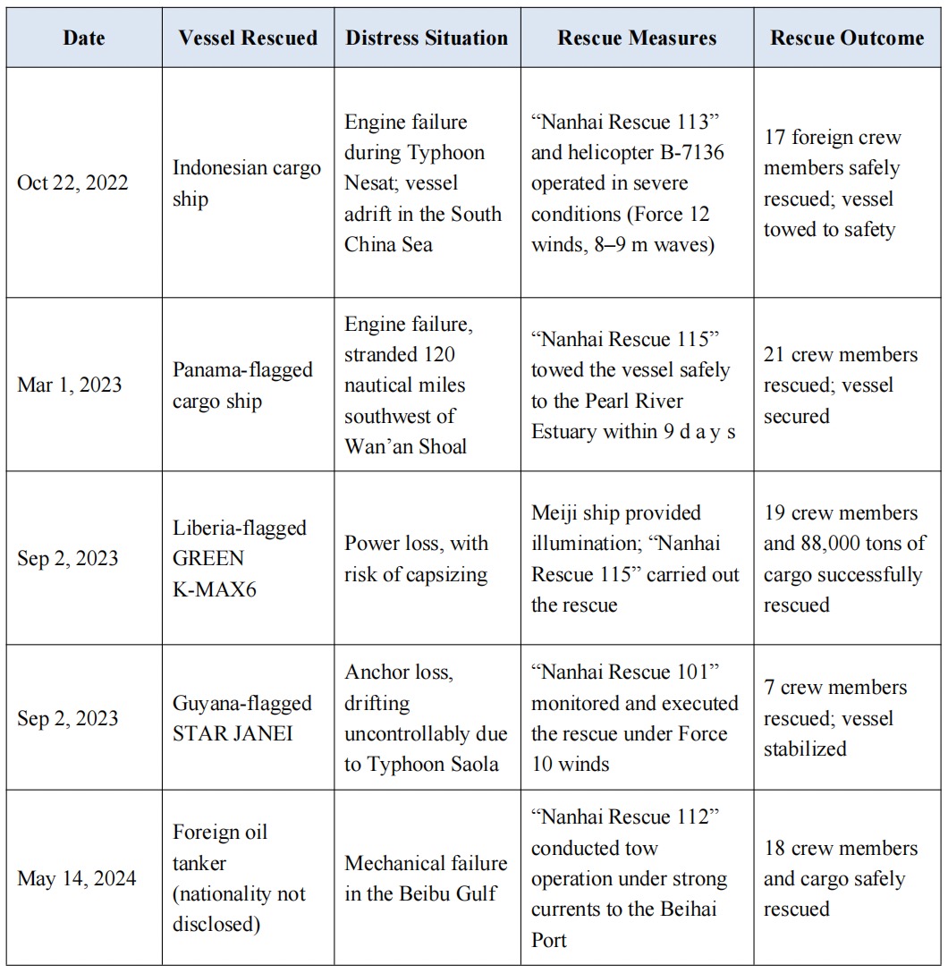
Table 1: Representative Foreign Vessel Rescue Cases in the South China Sea (2022-2024)[13]
Deepening International Cooperation Against Transnational Maritime Crimes
First, China is promoting rule-making and institutional mechanisms. Building on the Declaration on the Conduct of Parties in the South China Sea (DOC), China is actively advancing consultations to incorporate cooperation against piracy, smuggling, drug trafficking, and other transnational crimes into the framework of the Code of Conduct on the South China Sea (COC). Through institutional design, these efforts aim to strengthen regional security governance and lay the regulatory foundation for enhanced international cooperation.
Second, China is strengthening international cooperation in anti-piracy efforts. As a core member of the Regional Cooperation Agreement on Combating Piracy and Armed Robbery against Ships in Asia (ReCAAP), China has actively promoted information sharing and joint operations. In June 2024, China hosted a capacity-building seminar organized by the ReCAAP Information Sharing Centre, with participation from 14 countries including the Philippines, Singapore, and Vietnam. Representatives shared best practices and enhanced real-time data interoperability through the ReCAAP information network, significantly improving the region’s capacity to counter piracy and armed robbery.[14]
In parallel, China continues to deepen maritime law enforcement cooperation and joint exercises with neighboring countries. Since 2006, China and Vietnam have maintained a stable joint patrol mechanism in the Beibu Gulf, conducting biannual patrols that have become a model of regional collaboration. The April 2025 patrol featured China’s Xisha and Yongxing Coast Guard vessels and Vietnam’s 8004 and 8003 ships, patroling 255.5 nautical miles. For the first time, the patrol included a maritime search and rescue (SAR) drill, marking a shift from traditional law enforcement toward broader maritime safety cooperation.
China has also expanded bilateral maritime cooperation with Singapore. In May 2025, the “China-Singapore Cooperation 2025” joint maritime exercise was held at Singapore’s Changi Naval Base and surrounding sea and airspace. The drill focused on non-traditional security operations such as maritime search and rescue and logistical support, reflecting the growing scope of China-Singapore maritime cooperation and their shared commitment to a safer, better-monitored South China Sea.
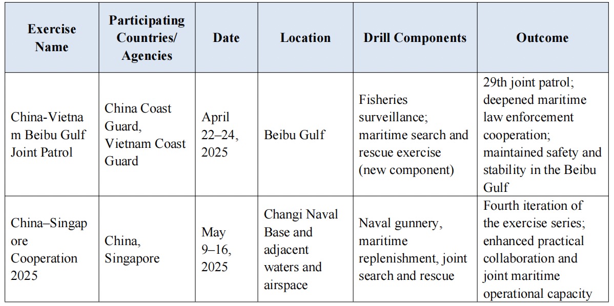
Table 2: Representative Joint Maritime Law Enforcement and Security Exercises Conducted by China in the South China Sea in 2025[15]
Third, China has established a maritime law enforcement framework that integrates routine surveillance with specialized enforcement operations. The China Coast Guard (CCG), the country’s primary maritime law enforcement agency, handled 601 smuggling cases in 2024, dismantled 32 criminal networks, solved five major drug trafficking cases, and seized 3.8 tons of narcotics. It also conducted over 20 joint operations with the National Immigration Administration to safeguard border security and combat illegal immigration, resulting in the arrest of more than 130 suspects.[16] Since the launch of the national 95110 maritime emergency hotline in 2019, the CCG has received nearly 310,000 reports. These have led to the resolution of more than 5,900 cases involving smuggling, drug trafficking, and illegal border crossings. In 2025, the CCG’s South China Sea Division launched a series of targeted operations, including “Clean Sea” and “Thunderbolt”, which yielded concrete results in suppressing maritime crimes such as smuggling and drug trafficking.[17]
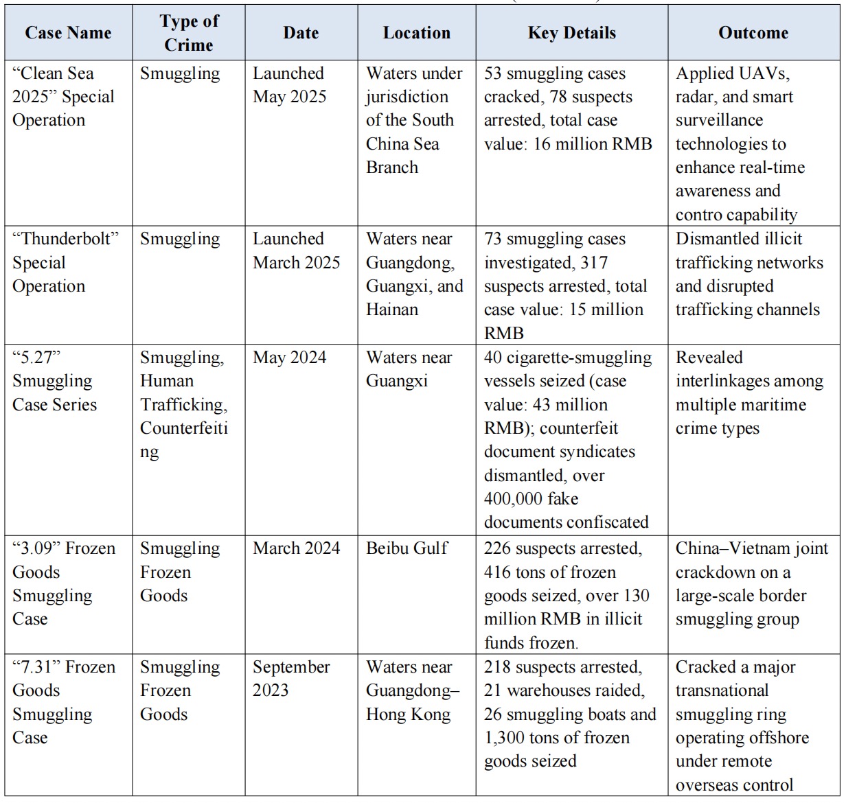
Table 3: Representative Cases of Transnational Maritime Crimes Addressed by the China Coast Guard in the South China Sea (2021-2025)[18]
Over the past 70 years, China’s role and contributions in safeguarding maritime safety in the South China Sea have been widely recognized. Especially in the past decade, China has made steady and commensurate contributions through initiatives such as providing intelligent navigation services, strengthening maritime disaster prevention and mitigation, developing an integrated sea-air search and rescue system, and deepening international cooperation against transnational maritime crimes. These efforts have fully demonstrated China’s commitment as a responsible major country. Looking forward, China will continue to uphold the principles of mutual respect, win-win cooperation, and shared safety, and will further contribute to maritime safety in the South China Sea, helping to promote peace and stability across the region.
Reference
[1] BeiDou Navigation Satellite System. 100% Coverage! BeiDou Supports Maintenance of Sansha navigational aids [EB/OL]. (2021-03-05). http://www.beidou.gov.cn/yw/xydt/202103/t20210311_22028.html.
[2] Ministry of Transport of the People's Republic of China. Launch of Large Maritime Navigation Aid Vessel "Haixun 176" [EB/OL]. (2024-11-07). https://www.cma.gov.cn/2011xwzx/2011xmtjj/202305/t20230526_5534381.html.
[3] China Meteorological Administration. Observing Clouds and Rain for 56 Years in the South China Sea, Sansha's Meteorological Development Embarks on a New Chapter [EB/OL]. (2023-05-26). https://www.cma.gov.cn/2011xwzx/2011xmtjj/202305/t20230526_5534381.html.
[4] National Meteorological Science Data Center. FengYun B Satellite First Image Released, Celebrating the CPC Centennial with Unprecedented Clarity [EB/OL]. https://data.cma.cn/site/article/id/41094.html.
[5] China Meteorological Administration. Drawing the Blueprint, Demonstrating Responsibility—FengYun Satellite Services Advance Belt and Road Initiative [EB/OL]. (2024-11-27). https://www.cma.gov.cn/ydyl/202411/t20241127_6712779.html.
[6] National Ocean Technology Center. Ocean Technology Achievements Spotlight—Tsunami Early Warning Buoys [EB/OL]. (2023-05-26). http://www.notcsoa.org.cn/cn/index/show/3960.
[7] National Natural Science Foundation of China, Center for Science Communication and Achievement Transformation. China's Independently Developed Global Storm Surge and Tsunami Monitoring and Early Warning System Officially Launched [EB/OL]. (2023-05-16). https://www.nsfc.gov.cn/csc/20340/20289/64905/index.html.
[8] Yang Huaiwei. Experts Train on South China Sea Regional Tsunami Early Warning Techniques. China Natural Resources News [EB/OL]. (2021-12-21). https://www.mnr.gov.cn/dt/hy/202112/t20211221_2715233.html.
[9] China Daily. Source Codes of “Mazu” Series Ocean Numerical Forecasting Models Released as Open-source [EB/OL]. (2024-11-20). https://cn.chinadaily.com.cn/a/202411/20/WS673d7d16a310b59111da46e5.html.
[10] Guangming Daily. “China Rescue and Salvage Saves 57,145 Lives Amid Stormy Seas Over 60 Years [EB/OL]. (2022-8-25). https://www.chinanews.com/sh/2011/08-25/3282647_2.shtml.
[11] Ministry of Transport of the People's Republic of China. Transport Rescue Completed 28th Regular Rotation for Nansha Islands Emergency Standby [EB/OL]. (2025-04-17). https://www.mot.gov.cn:10443/jiaotongyaowen/202504/t20250417_4167093.html.
[12] CCTV.com. China's Largest Deep-sea Multi-functional Rescue Vessel Put into Operation, Capable of Carrying Large Rescue Helicopters [EB/OL]. (2024-01-30). https://news.cctv.com/2024/01/30/ARTIQZEQPaF5HlnbfqelShMT240130.shtml.
[13] Compiled based on information published by the South China Sea Rescue Bureau, Ministry of Transport of the People’s Republic of China.
[14] ReCAAP Information Sharing Center. ReCAAP ISC Welcomes its 7th Executive Director [EB/OL]. (2025-04-02). https://www.recaap.org/resources/ck/files/news/2025/Press%20release%20-%...(2%20April%202025).pdf.
[15] Compiled based on public releases from China’s Ministry of National Defense and the China Coast Guard.
[16] People’s Daily Online. China Coast Guard strengthens crackdown on maritime crimes [EB/OL]. (2025-01-27). Retrieved from: https://en.people.cn/n3/2025/0127/c90000-20270979.html.
[17] Xinhua News Agency. China’s 95110 Coast Guard hotline has handled nearly 310,000 reports in five years [EB/OL]. (2024-07-10). Retrieved from: https://www.news.cn/politics/20240710/8856f1e6fc884fe399e5f9eeeb6612dc/c....
[18] Compiled based on public releases by the South China Sea Branch of China Coast Guard.
Yu Minna

Yu Minna, Lecturer, Law School of Ocean University of China. Her research focuses on international law, maritime law, and polar governance.